
The other day, I was on a nice longer bike ride to Powell Butte and decided I’d freelance my way home on whatever greenways I could find. Since I decided this at the corner of 89th and Ellis, the first greenway I stumbled on was the 80s. It’s not a part of town I’ve ridden extensively, though I am sure I’ve used it to get to a Pickles game before, which generally meant that I was at the mercy of street wayfinding signs to get me to the Clinton-Woodward bikeway.
So how did it go? Well, to begin I got a bit confused at Holgate, where a posted dead-end sign does not include “except bikes”, and there are no clear wayfinding signs or markings.
Then, I got to experience the confusion and pleasure of doing the infamous “just sort of navigate your way through a mall parking lot and access road with no signs” stretch between Holgate and Bush. Yes, there was a sharrow arrow correctly pointing me onto the sidewalk that skirts around the loading area for the Hong Phat, but uh… it’s not super ideal.


I then followed the unmarked pseudo-greenway behind the former Walmart, featuring some of those super steep old-school speed bumps that really suck to ride a bike over, and guessed correctly that the designated route would be 86th, rather than 84th.
The only reason I think I was able to navigate this with any amount of confidence was that I happened to know ahead of time that this stupid route went through Eastport Plaza. How PBOT expects anyone to navigate this area is beyond me1.
On 86th I had some very faded sharrows that at least told me I was on the right path, only to reach the dreaded light with Powell. Looking at the official Portland Bike Map, there’s an advertised “sidewalk connection”, but there are no signs to tell you this. That didn’t cross my mind, and I had good light timing so I just rode the half block down Powell. I just happened to guess correctly that the greenway (now an actual greenway again) continued to my left.


Safely back on a “regular greenway”, I knew my turn for home would be a well-marked, obvious choice at either Clinton or Woodward – roads I happen to know are between Powell and Division. Much to my surprise, I reached Division without seeing a wayfinding sign. Of course, I could have just taken the acceptable, if stressful, bike lane on Division to cross 82nd, this would have involved crossing Division an extra two times, and I was trying to do the greenway thing!
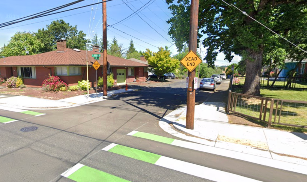
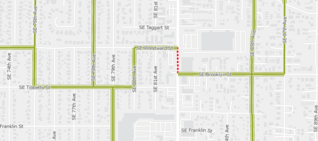
So I doubled back to Brooklyn, spotted a faded sharrow and followed it to the promised land …. of the worst connection of any greenway in the entire city. I’ve used this crossing of 82nd at Woodward on rides before, and happened to know that there are a few markings guiding you along the sidewalk from Brooklyn to the light at Woodward, but the sharrow pointing you directly into traffic on 82nd suggests otherwise.

Why is this marked as a “difficult connection” on 82nd itself, rather than a sidewalk connection (that does have a green thermoplastic sign) is beyond me. Even as someone with a strong appetite for reckless riding, taking the lane for a left turn from 82nd to Woodward is a bit much, especially when a marked sidewalk connection exists.
Once I got across 82nd (after narrowly avoiding a right hook from a driver making an illegal turn), I had a straightforward ride back. Well except for the construction on Tibbetts which had no marked detour for cyclists. But that’s an easy thing to avoid for me, I just headed back up to Woodward to shred some gravel roads to get back on track. It was not exactly an ideal experience from start to finish, but I’m certain I learned something important – don’t bother crossing 82nd on a bike unless you are absolutely certain of what roads you want to take on the way back.
Does This Even Matter?
Look, I get that the ramblings about how annoying it was to follow this greenway without looking at a map are sort of silly. Most people would easily resolve this by looking at a map. I realize that my dislike of GPS-based navigation makes me something of a Luddite. But I think this horrible greenway experience matters for two reasons. First, it’s just not pleasant for a route to be so unintuitive that you have to constantly double check you’re on the right path, and this route is chock-full of times where even experienced riders would have second thoughts. If you want people to actually ride bikes, this is a very strange way to go about it.

But there’s also some planning implications for greenways like this. Since PBOT considers this to be a genuine greenway (albeit an incomplete one), when projects like the 82nd rebuild get under way, they strategize as if this is a totally legitimate and straightforward way to get around this part of Portland on a bike.
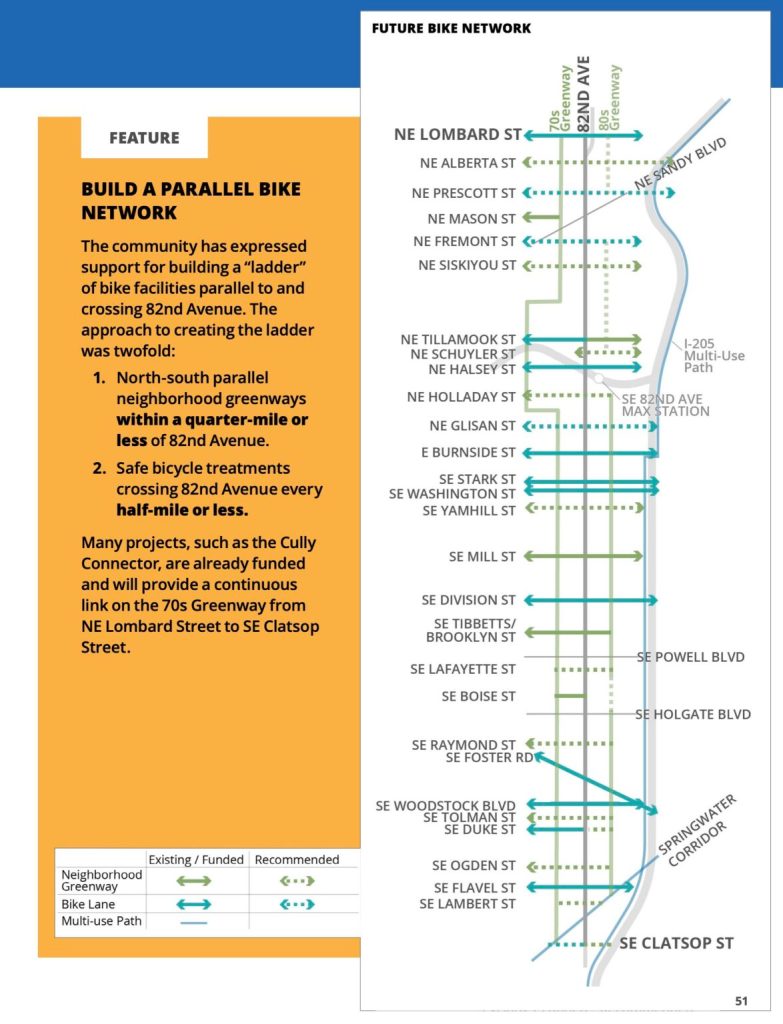
For 82nd, this has manifested in the “bike ladder” concept (left). While my general opposition to this concept is well documented elsewhere2, even if the entirety of this “ladder” were to be built out, neither point one (parallel greenways within a quarter mile) nor point two (perpendicular crossings every half mile or less) would be achieved.
Let’s begin with the second point: “safe bicycle treatments crossing 82nd avenue every half-mile or less”. It’s easy to look at that diagram and think, “well that’s a lot of crossing lines, must be way better than that”. You would be wrong to think this though. Fremont to Prescott is just over half a mile3, as is Siskiyou to Tillamook. These are maybe close enough to call “half a mile”, but between Lafayette and Raymond is two-thirds of a mile. Sure, Boise is in between them but it also is apparently not recommended to connect all the way to the 80s “greenway”4. In keeping with the ladder analogy, it’s hard to feel like half-rungs really count. Would you step on that rung? It’s a crossing to nowhere.
Other crossings – like the Tibbetts/Brooklyn one – seem likely to be dubious sidewalk connections. A whole lot of ink has been spilled about how there’s “no room” for bikes on 82nd, so an in-road jog (like you see at many off-kilter bikeway intersections in Portland5) seems unlikely. So it’ll be a sketchy sidewalk thing I assume. The Raymond and Ogden crossings will be like this, along with Tibbetts/Brooklyn.
Most of these new recommended/planned crossings also have dubious value as traditional “neighborhood greenways”. They are likely to dead end shortly after the 70s/80s greenways (since the streets they are on do as well), and will provide little utility beyond the improved crossings of 82nd. This is valuable, but a glance at the ladder diagram significantly overstates how useful these will be in practice for every day riding6.
For the first point: “north-south parallel greenways within a quarter-mile or less of 82nd Avenue“, this is simply not true. The furthest point on the 70s greenway from 82nd is a full two-thirds of a mile (at the corner of 72nd and Sacramento) as the crow flies, and is even further in reality (since Sacramento dead-ends at 77th). The result of the 70s jog through the golf course is that even if all of these projects get built in full, traveling from Siskiyou and 82nd to Holladay and 82nd will be a 2.1 mile journey – 110% longer than the 1 mile journey along 82nd will be.
But things get worse when you consider that given the relatively poor street grid around 82nd, a quarter mile in practice is very different than a quarter mile as the crow flies. To illustrate this, I calculated the actual network walking distance from a series of pseudo random points along 82nd7, and compared that polygon of equal travel distance8 to the existing and planned greenway facilities (see above map).
By this method, just 3.82 of the 8.29 miles of the 70s greenway is within a quarter mile of 82nd, while 1.97 of the 4.67 miles of existing 80s greenway is9. All told, just 45% of parallel greenways are within a quarter mile of 82nd in practice. That’s pretty egregious.
I think that PBOT’s approach here has been somewhat insulting as bike rider. These parallel greenways are exceedingly annoying to use in practice10, especially if you need to get between two places on or around 82nd. Nothing says “prioritizing and environmentally sustainable mode of transportation” quite like “imposing a 110% distance penalty”. But the “ladder” approach is presented as if it’s some quality feature, even though it plainly is not.
I’ve posted extensively on this blog about the existential shortcomings of Portland’s greenway-based bike planning, but 82nd is really where the system breaks. The fact that PBOT couldn’t even suggest even a half-assed connection between these bad greenways and literally the busiest stop on the busiest bus route in the state is ridiculous11. Instead, the 70s greenway diverts all the way to 74th, while the 80s greenway just ends. I-84 is a huge barrier, and this ladder plan simply doesn’t address that.
Even though transit needs to be our highest priority on 82nd12, the exclusion of bikes in the rebuild is a generational mistake. The parallel greenways are simply not adequate, and even though some of that is fixable (any amount of signs would be nice), most of it is not. They are too far away from 82nd to be good alternatives for travel along it in any way, and they are too convoluted to be an articulatable part of the transportation network.
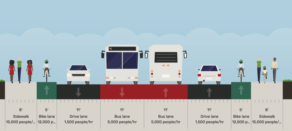
But there is room for all our needs to be met in the 82nd area, just not with the current plans. By creatively utilizing our busway to be “single-tracked” when other needs exist (such as platforms or left turn lanes), it would be entirely possible to have a semi-BRT13 with actually good bus lanes. Bike lanes, wider sidewalks, and better transit can be shoe-horned in, while the majority of car access can still be maintained14. The fact that we haven’t done this isn’t just about de-prioritizing bikes, but also a seeming lack of imagination and familiarity with innovative solutions. Hopefully, there’s still time to fix this – but I’m not holding my breath.


That’s all for now, thanks for reading and I’ll see you next time.
Footnotes
- Incidentally, Google suggests a more straightforward route that avoids the mall parking lot in favor of cutting through the nearby school ↩︎
- Like in this lovely post you can read at your leisure ↩︎
- I measured 0.502 miles on Google, so maybe you feel like rounding down is fine, but I’m being annoying on purpose here. ↩︎
- This is the section where it runs through the mall parking lot ↩︎
- Like this one on NE 33rd ↩︎
- This is before we even consider if/when these will ever be built. PBOT promised perpendicular greenway designation and improvements after the Hawthorne push-back, but have yet to deliver any of them, and all but one of the suggestions has fallen off official greenway plans (34th remains) ↩︎
- These points are the centroids of each OpenStreetMap way that constitute 82nd Ave. Most of them are about halfway between intersections, but not all. ↩︎
- Also called an isochrone ↩︎
- The planned disconnected northern sections of the 80s greenway aren’t included, mostly since I am not confident about the specific routing choice. Also, if my ladder had one side with missing supports I wouldn’t use it. ↩︎
- I considered also making a 70s greenway review here, but that will have to wait for another day ↩︎
- I’m talking about the 82nd/MAX bus stop – which sees some 1,800 riders daily in each direction. Only transit centers and MAX stops see more ridership (source) ↩︎
- Incidentally, I think the “bus and turn” lane approach is incredibly bad on a corridor like 82nd. Can’t wait for the buses to be stuck in the same traffic as the cars, since most people will just be turning right into driveways and onto other roads anyways. This project always should have been a center running busway. ↩︎
- Even though I say “semi-BRT” here, most planners would call a center running busway “BRT”. I think this particular design would maybe not need to be full BRT (in the Latin American sense), and prefer to use a CDMX Metrobus route as my “standard BRT”, rather than some half-assed American one running 15 minute service (sorry Albuquerque). ↩︎
- There would be fairly significant reductions in left-turn driveway access, as the designs allow only uni-directional left turns. I guess you could allow traffic to cut across the busway from the other direction, but I think this isn’t ideal. It’d be a conversation worth having at least. ↩︎

Leave a comment