
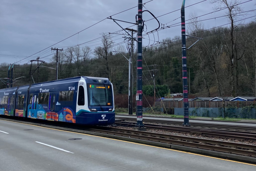
This post is a companion piece to this article in the Seattle Transit Blog
What’s old is new again: Sound Transit is set to choose to defer Graham Street Station in light of a budget shortfall. I’ll spare the gruesome details of the context of how we got here, and how the crisis could be addressed in other ways1, and will instead journey into the abyss of an April 2025 Alternatives Development Memo for the station itself. As is usually the case here, a lot can be learned about how an agency approaches risk and what they value in what they consider to be practical.
But before we begin, it’s worth noting that the reason to re-explore this station choice is functionally dependent on the station being indefinitely deferred. The choice in Spring 2025 of a center platform south of Graham Street was a final one in terms of environmental review and planning, and there would have to be a good reason to revisit it. I am of the opinion that “running out of money” is a good enough reason, but I’ll leave it to you if you agree. Even so, it’s also noteworthy that the FTA has not actually approved the decision made last year yet, as no transit environmental reviews have been approved since the beginning of the second Trump administration2. So this hard line in the sand is potentially more like a soft line in the sand, but it’s still likely that revisiting the alternatives would delay the project.
Getting Situated
The intersection of Graham and MLK is a minor commercial node with shops, restaurants, and other local businesses. It’s about halfway between the existing Columbia City and Othello stations, which are a little over a mile and a half apart from each other3. This long distance between stations and obvious land use/commercial appeal is why Graham Street was originally planned to have a station, but its lack of intersecting bus service and lower profile compared to the other Rainier Valley stations are likely what caused it to be deferred in the first place.
Within the technical development memo, six station options are considered: side platforms north of Graham, center platform north of Graham, side platforms south of Graham, center platform south of Graham, and split platforms on either side of Graham.
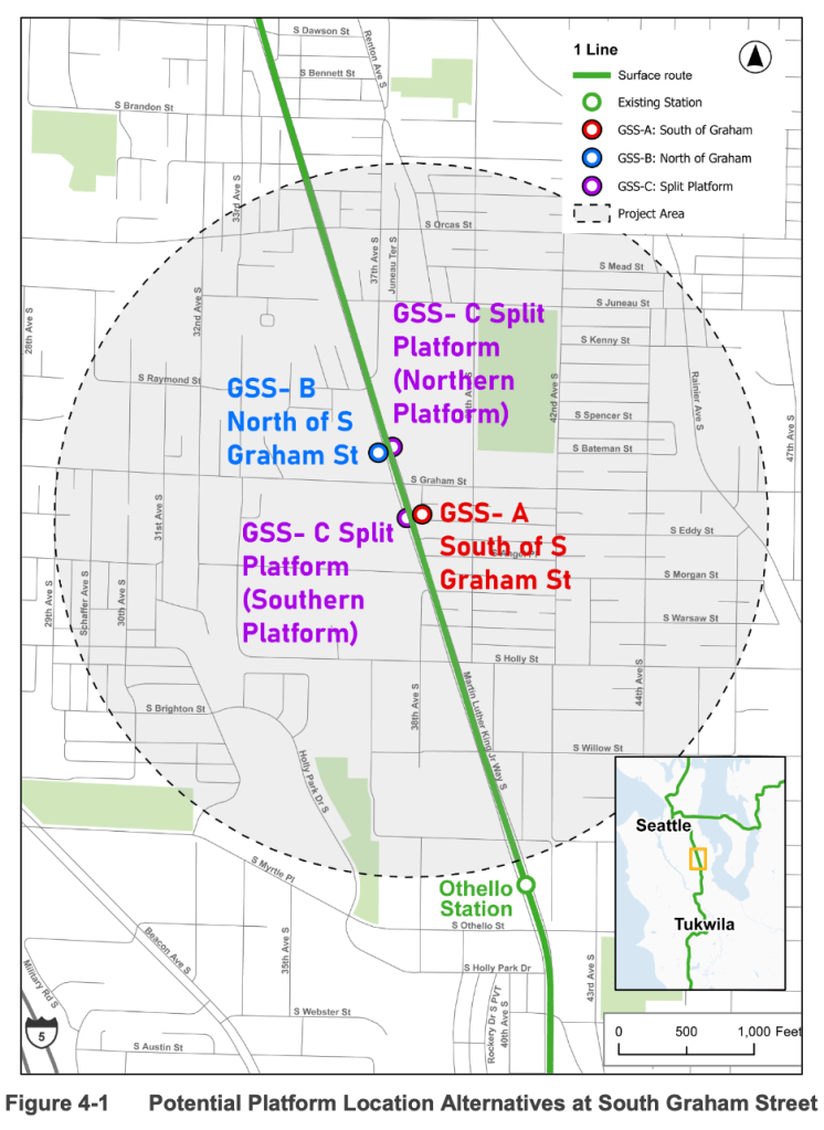
The first consideration for all six options is a simple screen to ensure that the options meet the purpose and need of the project, if any avoid all conflicts with sewer infrastructure in the area, and to see if any were to avoid potential areas of track that are not straight. All options pass these criteria equally, as the lack of straight track is a mitigating factor for all six platform options, as is the presence of sewer infrastructure.
Level 1 Evaluation
Since all six choices pass the initial criteria, they are evaluated qualitatively based on right of way needs, station access, long-term vehicle traffic impacts, multi-modal safety, constructability (defined as impacts to 1 Line service and construction timelines), racial equity, and environmental/cultural resources. There’s not a ton to unpack in why these are the criteria – but I want to dwell on the choice to consider long-term vehicle impacts briefly.
Within the report, the criteria are drawn from the station’s purpose and need and the poorly-defined (from a reader’s perspective) “ST3 compatibility criteria”4. Of the six bullet points identified in the project’s purpose and need statement, only one or two can reasonably be read as interested in long-term vehicle access (the “improve long-term regional mobility, multi-modal connectivity, and convenience” points).
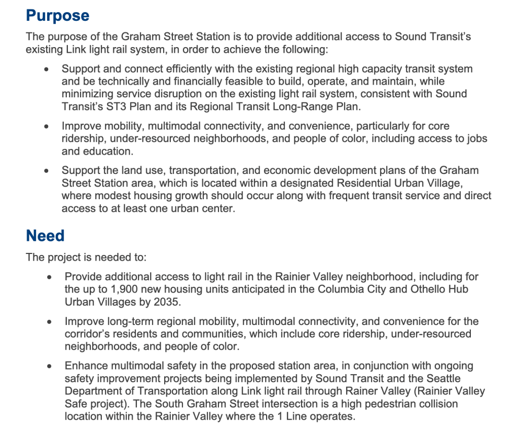
I don’t mean to imply that this is a disingenuous goal, but I do think making it a stand-alone criteria is problematic based on the project’s stated purpose and need. Improving multi-modal connectivity can really only partially be read as maintaining vehicle access and this specific criteria will be a sticking point as we evaluate the six options. And it’s also worth saying that reducing vehicle access is consistent with other aspects of the purpose and need – particularly as it relates to multi-modal safety.
But back to the Level 1 Evaluation. On right of way needs, the split-platform options perform the best because they significantly reduce the need to realign MLK or the tracks. While some additional right of way is needed in both cases (as the area where a platform would go is a bit too narrow right now – see below), it’s much less than the other options where significant acquisitions are needed to widen MLK on both sides of the intersection.
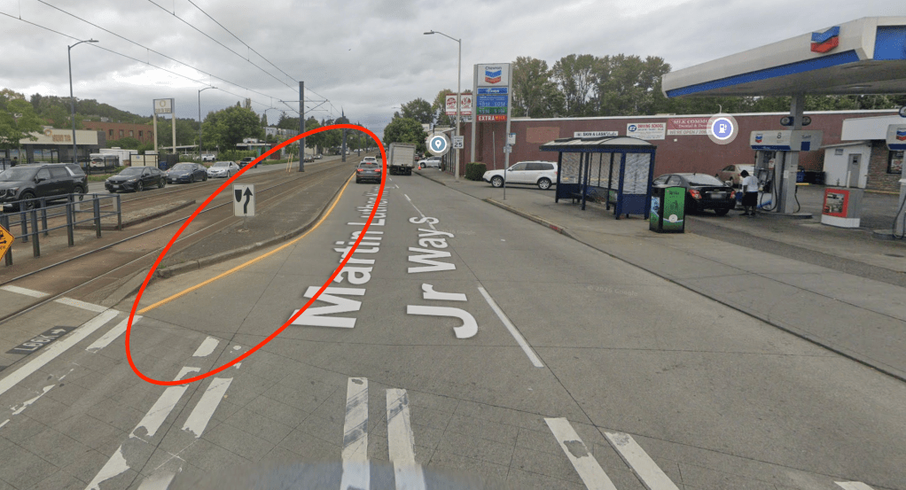
There are similar right of way impacts between the north and south options, with the center platform being ranked as lower impact for reasons mostly stemming from the center platforms being designed to impact only one side of MLK. But it’s important to clarify here that there is no consideration for removing a travel lane in any case, and that right of way impacts will likely be significant barriers to construction as a result. The intersection with Alaska at the Columbia City station is about 135 feet wide, while Graham Street is a mere 105 feet wide, so we are looking at about 30 feet of street widening (or a little over 2 lanes).
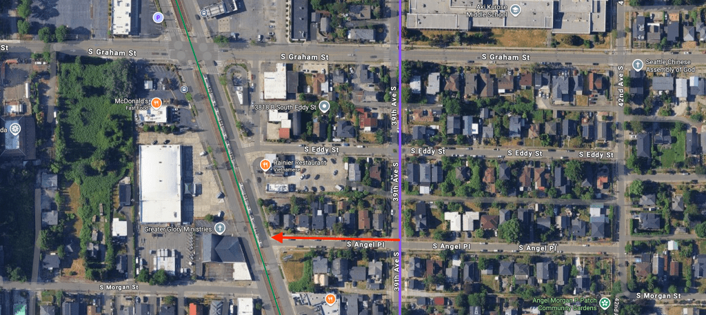
On station access, the only piece of note is that Sound Transit calls out a potential neighborhood greenway connection from the Hillman City Healthy Street on 39th Ave S (below, purple) via Angel Place (below, red). This means the near-side split platform option scores partial points, while the south of Graham platform scores best.
For long-term traffic and multi-modal safety, let’s consider them together because they should be linked. And to some extent, we do see this, as Option C2 removes the conflict points relating to left turns – a significant safety improvement for pedestrians and an operational improvement for the trains themselves.
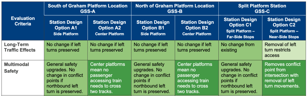
But we see that the center platform option also scores highest on multi-modal safety on account of removing the need for any passenger to cross two tracks to access a train. While this is a legitimate safety improvement in some ways, I don’t see any specific documentation detailing that this is a germane safety issue for pedestrians along MLK. Indeed, in previous reporting on Seattle Transit Blog, the number one safety concern for pedestrian is motor vehicles. Of course, rail-pedestrian crashes are a major issue on MLK as well, but it’s not clear if any of them specifically have to do with crossing two tracks at a station.
While this is an arcane point so far in the weeds that it feels irrelevant, the general trend for the alternatives report is to overstate the case for a center platform, and this is just one example of that. We’ll get a bit more into that specific point later, but I think it’s worth saying that the safety improvement from removing a turning conflict is more important than the safety improvement from removing the need to cross two railway tracks at once5.
The final point of interest is “constructability”. The criteria used is described as “Evaluation of potential space needs and duration for construction and the potential effects on 1 Line service” (emphasis added). In all cases, the only criteria considered are conflicts with existing sewer utilities (below).
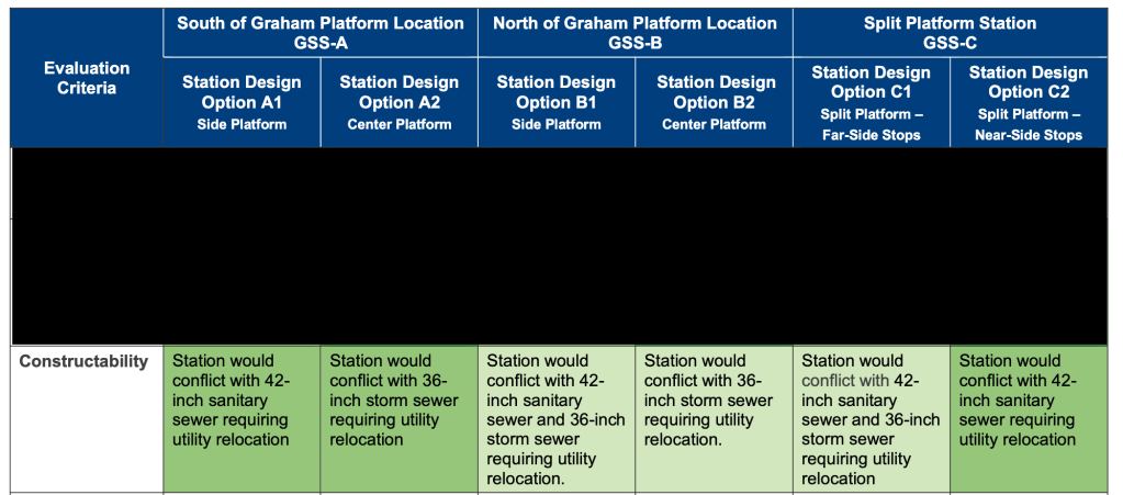
The key point here is that the northbound, south side of the intersection has no sewer constraints, while all others do (see below). This makes construction of any platforms north of the intersection more difficult. But notably, none of the projects are judged by the potential effects on 1 Line service. This is notable primarily because it stands to reason that the center platform options, which will require building new track and relocating and rebuilding the overhead catenary system in the vicinity of the station will be much more disruptive. Unfortunately I can’t provide an estimate to this, but I think this is a serious concern, or at least one you would expect to see addressed within the context of this report.
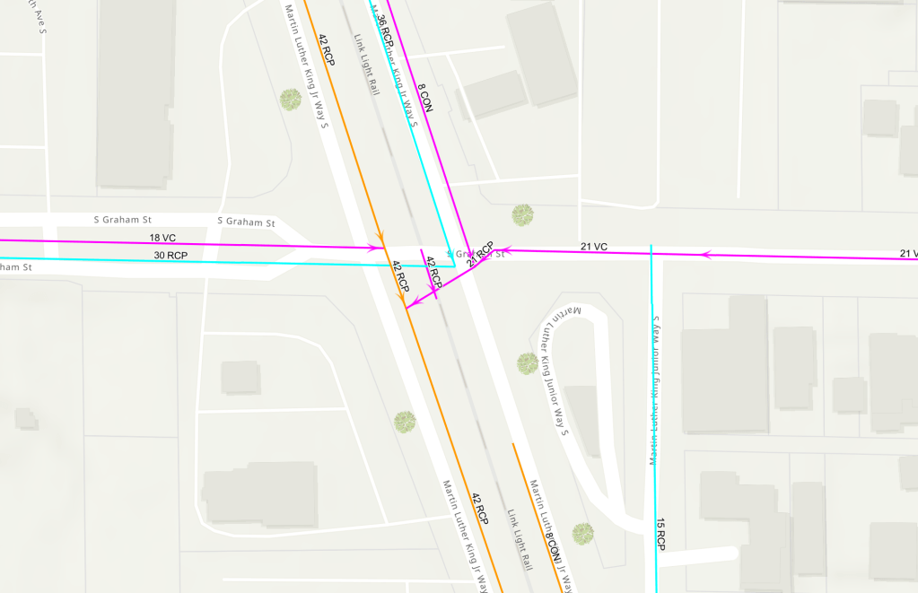
But wait – this concern is actually addressed within the context of this report! When discussing the implications of each option, the report mentions that “One consideration for GSS-A2 would be anticipated additional service disruption during construction caused by rail realignment necessary for the center platform configuration, resulting in a low Constructability rating” (emphasis added). This is sloppy work, as the constructability rating for the other options shaded in the medium green is medium. Does this actually matter? That’s not entirely clear to me. But it’s an unfortunate mistake, and one that stands out on a close read – especially in the context of multi-modal safety being already weighted more heavily towards the center platform choices.
The result of the Level 1 Evaluation is thus hard to take at face value. Both options for stations south of Graham are advanced, primarily on account of better access (because of the local street connection at Angel Place), while neither of the station options north of Graham are. Of the split side platforms, only the far-side platform is advanced. See the table below for the scores.
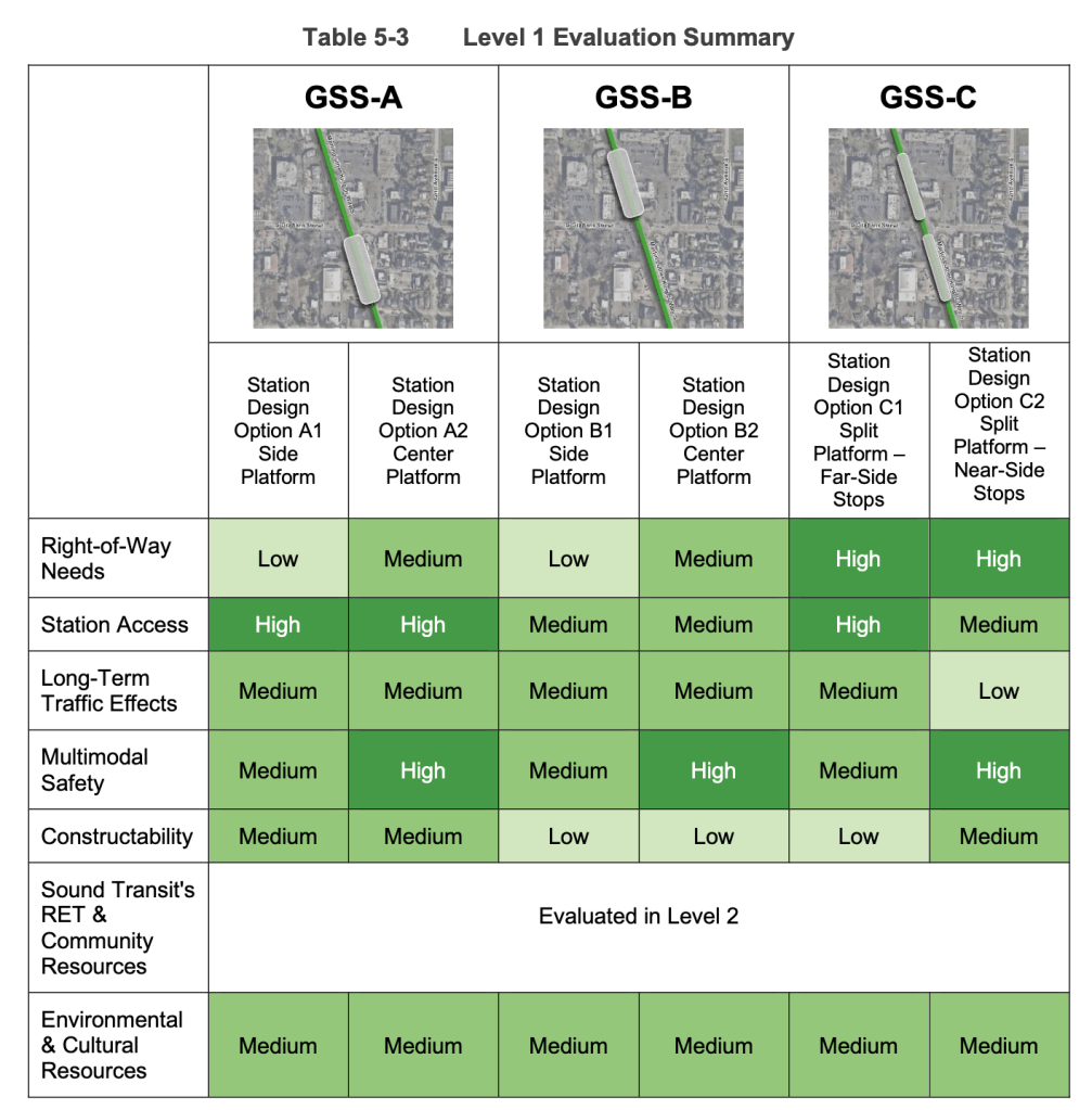
The eagle-eyed among you may note that it’s really not obvious that A1, A2, and C1 should be the three choices for further evaluation. Even before accounting for the fact that the constructability of option A2 is simply wrong, A1 scores worse than C2. And with the correct constructability score, A2 is equal with C1 and C2.
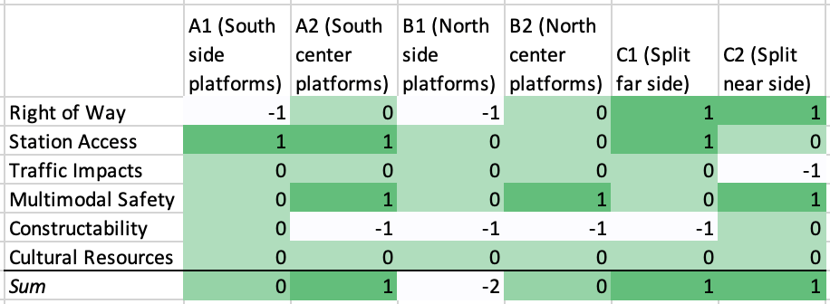
A simple sum may not be the way alternatives were actually advanced, but the qualitative discussion of which alternatives should advance is sorely lacking. A close read of the report should not leave you with more questions than when you started.
Levels 2 and 3
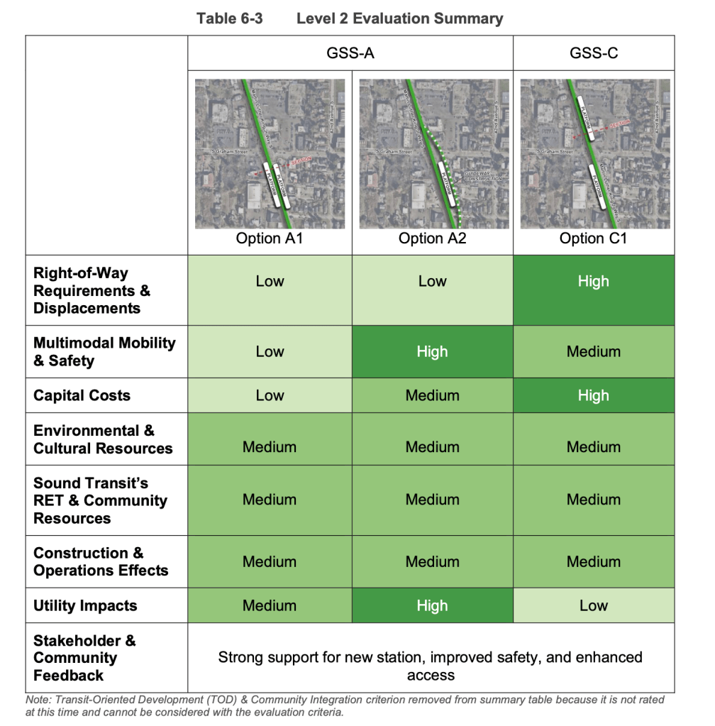
Above we see that after further refinement, Option A1 is ruled out, while Options C1 and A2 are tied. Despite this, the text of the report boldly states that “Based on the Level 2 Evaluation, GSS-C1 did not provide additional benefits over GSS-A Option A1 and Option A2.” This is, again, not obviously true from the information shown in the report. Option A1 scores the lowest, and it’s really not close. It’s ultimately a bit of a moot point, since the final level of evaluation does in fact follow the evaluation table, with an additional construction option for A2, but it’s another gaffe in the report that bears mentioning.
And we also see that despite the fact that option A2 involves construction of new track and at least some overhead catenary work, it scores the same as the two side platform options where the only track work required is based on internal standards for perfectly straight track. I’m not a railroad construction expert, but I feel that is a significant difference. No trains will be running while the catenary is being reconstructed, and building new tracks is surely more time-intensive than minor alternations to existing ones.
Level 3 is more of the same. The issue I’ve been droning on about for constructability is not addressed, but community stakeholder preferences for a center platform are introduced. From the onset, I want to say that I also prefer a center platform if I’m left to my own devices, but it’s worth emphasizing that choosing a center platform for an existing right of way is extremely unusual. Of my review of infill stations on light rail systems in the US, I could only find one potential example of a center platform infill station that wasn’t explicitly planned – 900 South 400 West in Salt Lake City – and that station cost $1.3 million to Graham Street’s $118 million.
The final evaluation table bothers me for a lot of reasons – not least of which being that there is obvious double-counting of certain aspects. But based on the results of option C1 from the first two levels, I think there’s a fair case that option C2 would have been on par with the selected choice. But ultimately, the only options presented to the public for further comment were the three options south of Graham.
Inferring the Why
Ultimately, reviewing an alternatives report like this in detail is almost always an exercise in futility. The decisions rarely are justified in any kind of rational way, and they are almost always used as a way to justify whatever decision people already wanted6. From this cynical perspective, it’s worth asking why Sound Transit would prefer a center platform that’s almost certainly driving costs up over a side platform that would be more typical of a bog-standard infill station on a light rail line.
Within the Spring 2025 reporting by the Urbanist, the Sound Transit planner quoted mentions that a major consideration was that service disruptions are common in Rainier Valley, and a center platform allows for operational flexibility during times like that. This, alongside the claimed community preference for a center platform ultimately are the most plausible explanation as to why the station is planned to be located where it is.
Are those good reasons? If you squint. But I think that leveraging the specter of more reliable service through a crossover and one center platform is deeply irresponsible while the structural conditions that cause unreliable service are left unaddressed. That structural reason is that cars hit trains and trains hit cars, because Sound Transit and SDOT don’t want to slow car traffic down by adding full crossing gates. If we want to make Link in Rainier Valley safer and more reliable, choosing a center platform at Graham Street is hardly impactful.
Previously, I talked about how Sound Transit should prefer to close the left turns at Graham Street even if no station were being built. There are seven left turns allowed across the tracks between on the 3.5 miles between Mount Baker and Rainier Beach. Every one of those is currently slowing a train down as it slogs down MLK. This should not be an acceptable operating environment for Sound Transit, but perhaps since they outsource 100% of their train operations to King County Metro they are uninterested in actually improving operating conditions.
Rather, they can posture as an agency more concerned about regional mobility than just the small nuisances that go into maintaining and operating a cobbled-together system like Link. From this vantage point, maybe it does make sense to preserve all those left turns in the name of regional mobility – after all, those drivers are going somewhere. Maybe it’s just because I’m still new to town, but I cannot interpret the sheer banality of a train filled with hundreds of people stopping at Oregon to allow three cars to turn left less than 800 feet from another left turn at Alaska as anything other than a clear message that transit riders do not matter to Sound Transit7.
This baked-in preference towards compromise and accommodation isn’t unique to Sound Transit – it’s close to the typical posture of a transit agency in the US. But those of us who have read about the history of transit in our cities, or who have been to places where they actually care to make transit as fast and comfortable as it reasonably can be know better. The death of the streetcar came in no small part because car drivers explicitly wanted to relegate transit to the slow side of the road, a piece of history that every person who has ridden a bus instinctively knows. We suffer through cars refusing to yield as they pass our bus that has to pull out of the travel lane to serve a stop, and this norm came about because automotive interests dictated it. It didn’t used to be this way.
On South Graham Street, the same thing is happening. A cheaper option that would inconvenience some drivers is dismissed out of hand, while our worlds-most-expensive8 infill station gets kicked down the road because we don’t have enough money to build it. Sure, I’d like to simply have that money too and I am absolutely willing to pay more for a better station, but I do not believe a transit agency should be willing or able to dismiss good options based on potential delays to car traffic.
If Marx believed that “the history of all hitherto existing society is the history of class struggles” then I believe that the history of public transit is the history of the struggle between automotive dominance of roadway space and more efficient and practical alternatives. It’s a shame that my local transit agencies seem to disagree and that we’ll end up waiting another 30 years before one infill station can be built as a result.
Thanks for reading, ’til next time.
Footnotes
- Here are a handful of ideas on how to handle it, ranging from easy to difficult: Changing Sound Transit’s debt limit but not much else, Making the Ballard line into a standalone automated stub, completely re-planning the whole thing ↩︎
- You can find a list of FTA EIS decisions here ↩︎
- Graham Street is noticeably closer to Othello than Columbia City, so it’s not the ideal placement in terms of ridership coverage, but I think it’s a fine enough spot. ↩︎
- I cannot find a reference to the ST3 compatibility criteria anywhere, so if anyone knows what these criteria are, I’m all ears. ↩︎
- It’s worth saying here that the safety issues relating to two railway track crossing versus one can also be addressed separately, and should be anyways. The obvious choice is automatic crossing arms that block the pedestrian crossing as well. ↩︎
- Point in case: the PGE Harborton project that I wrote about last year. ↩︎
- To be clear, I don’t believe this to be true in general. I believe that the people who work for and who manage the regional transit agency care about transit riders. But they do not care enough to force changes to the operating environment to allow a train filled with people to have absolute priority over cars. And if they don’t advocate for this, who will? ↩︎
- This may not be literally true, but it sure feels like $118 million for an at-grade station would be close. ↩︎


Leave a Reply